Homepage
The objective of the new ESA initiative EO AFRICA (African Framework for Research, Innovation, Communities and Applications) is to build an African-European R&D partnership to facilitate the sustainable adoption of Earth Observation and related space technology in Africa.
EO AFRICA follows a long-term vision (>10 years) for the emergent digital era in Africa. Starting from September 2022, 10 new projects are being kicked off, involving African developers, research groups and early adopters. This project is one of the four EO AFRICA ‘National Incubators’ projects that investigate how sustainable agriculture and/or drought monitoring at a national scale can be achieved in the African continent, by co-developing innovative EO-based solutions with African experts.
ANIN South Africa Drought Monitoring
South Africa Drought Monitoring Service aims to increase the awareness of EO data potential to support the operation of added-value services in the field of drought monitoring decision making. The project aims to build a drought early warning system that is based on the continuous calculation of a set of satellite-based indices and indicators.
Partners
The target audience are South African governmental bodies, especially national agencies with a duty mandate to officially report indicators associated with the thematic domains. More specifically, the focus is the Department of Water and Sanitation (DWS), which has the mandate towards drought reporting and monitoring in combination with the Department of Agriculture, Land-Reform and Rural Development (DALRRD) which is involved in the climate section. The South African Weather Service (SAWS) Additionally, the project has the support of the Agriculture Research Council (ARC) in South Africa, the South African National Space Agency (SANSA) and the Centre for Coordination of Agriculture Research and Development for South Africa (CCARDESA)
About
Drought is a recurrent feature of all climates that results from a shortfall in precipitation over an extended period, its inadequate timing compared to the needs of the vegetation cover, or a negative water balance due to an increased potential evapotranspiration caused by high temperatures. These conditions may be exacerbated by strong winds, atmospheric blocking patterns and antecedent conditions in soil moisture, reservoirs, and aquifers among others. If this situation leads to an unusual and temporary deficit in water availability, it is termed a drought.
The European Space Agency (ESA)-funded ANIN project kicked-off on 13th of September 2022 and will last two years. The project aims to provide a Drought Early Warning system by calculating meteorological, agricultural, and hydrological indices based on satellite data.
Objectives
The ambition of the ANIN project’s team is to develop a drought early warning system for preparedness, mitigation and response with the following characteristics:
- Generating quality data to support a drought early warning system by combining meteorological, agricultural, and hydrological indices.
- Customizing EO information for specific user needs by answering practical questions for the users.
- Enhance drought capacity and decision-making mechanisms to bring drought forecasts to grassroots level.
- Integrating EO information with other information resources such as real-time weather forecasting, seasonal forecasts, and in-situ data from existing network information.
- Perform enhanced analytics and modelling to provide information that allows better decision-making.
- Facilitate decision-making by providing a drought monitoring by providing an open visualization platform.
Background
Drought is a recurrent feature of all climates that results from a shortfall in precipitation over an extended period, its inadequate timing compared to the needs of the vegetation cover, or a negative water balance due to an increased potential evapotranspiration caused by high temperatures. These conditions may be exacerbated by strong winds, atmospheric blocking patterns and antecedent conditions in soil moisture, reservoirs and aquifers, for example. If this situation leads to an unusual and temporary deficit in water availability, it is termed a drought.
Droughts are slow-onset events that can last from weeks to years. They are often defined as meteorological, agricultural or hydrological droughts. However, these are actually progressive manifestations of the same drought event propagating through the hydrological cycle. Recently, the concept of flash droughts has emerged, describing quick-onset, severe events of water stress due to high temperatures and a high evaporative demand.
Figure 1: Schematic representation of drought propagation through the hydrological cycle, related drought stages and key indicators.
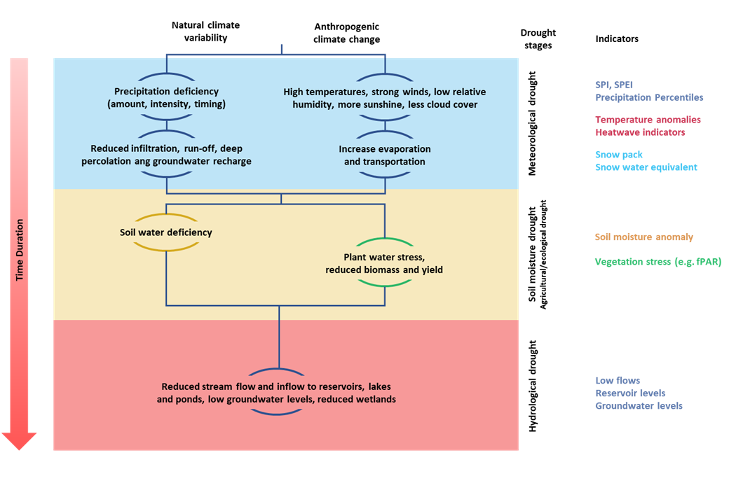
Source: UNDRR, 2021, adapted from the National Drought Migitation Centre; Wilhite et al. (2014).
Due to the different types of droughts, its monitoring is based on the analysis of a series of drought indicators and indices, representing different components of the hydrological cycle (e.g., precipitation, soil moisture, reservoir levels, river flow, groundwater levels) or impacts (e.g., vegetation water stress). Usually, indicators represent statistical anomalies of the current situation with respect to the long-term climatology at a given location and time interval.
South Africa is one of many African countries vulnerable to droughts, as climate change projections show that more frequent and intense droughts and increased warning are anticipated. Therefore, there is a need for more scientific research on drought impacts, drought indicators and responses by vulnerable groups such as smallholder farmers. In recent years, an ongoing period of drought has taken place in Southern Africa. In the late 2015 – early 2016 season, an El Niño event caused a drought in some parts of Southern Africa and as of the start of the 2018-19 El Niño-induced drought, some parts had not yet recovered from the effects of the earlier drought. In 2021, the South Africa National Disaster Management Centre declared a drought disaster due to the persistent drought conditions in the Northern Cape, Eastern Cape and Western Cape.
Because drought occur gradually, are widespread, and often indiscernible until a more significant loss, e.g., loss in productivity, has been experienced, the impacts of droughts can be devastating in the short and long-term time scales. One of the alarming consequences of droughts is the decline in river flow, groundwater recharge, runoff, and dam-levels, ultimately affecting various socio-economic sectors. Moreover, low precipitation and high temperatures during droughts result in rapid moisture loss from plants and soils (through evapotranspiration), causing significant losses in agricultural productivity and incomes, habitats, and ecosystem services. For example, the 1992 droughts in South Africa led to approximately 70% in crop failure, livestock deaths, and malnutrition in humans. Therefore, information on drought early warning and monitoring for preparedness, mitigation, and response is dire and requires urgent attention from multi-sectoral stakeholders.
News
ANIN WORKSHOP, Pretoria. April 9th and 10th. Earth Observation for Drought Monitoring and Early Warning in South Africa
The event at the Innovation Hub in Pretoria, South Africa, represents a pivotal gathering aimed at bolstering the application and understanding of Earth Observation (EO) data in enhancing drought monitoring and decision-making.
Workshop Objectives:
- Foster Awareness: Increase awareness among stakeholders about the potential of EO data to support added-value services in the field of drought monitoring and decision making.
- Encourage Collaboration: Promote collaboration among key stakeholders, including government bodies like the Department of Water and Sanitation (DWS) and the South African Weather Service (SAWS), as well as participants from the EO Africa program and other relevant entities.
- Strengthen Capacity: Identify capacity gaps and needs in the access and use of EO data for drought monitoring, aiming to enhance technical and operational capabilities.
- Innovate Solutions: Explore and develop innovative solutions for the integration of EO technologies in existing and future drought monitoring and early warning systems.
- Sustain Impact: Develop strategies for sustaining the impact and uptake of EO services for drought monitoring beyond initial financial support, ensuring long-term viability and effectiveness.
Here is the full program of the event: ANIN Workshop
ANIN Project Contributes to Successful Discussion at GEO Week & Ministerial Summit
We are thrilled to share the success of the ANIN project's participation in the recent GEO Week and Ministerial Summit, held from November 6-10 in Cape Town. The project took center stage during the event's highlight, the round table organized by AgroApps PC and GMV, titled "Enhancing African Agriculture through Earth Observation: Insights from AfriCultuReS, ANIN, and Afri4Cast Projects."
Representatives and members of the ANIN consortium.
A story map is a powerful tool to tell our story, it's dynamic, interactive and visually engaging. It helps us to simplify complex information in a user-friendly manner. An innovative way to present data, educate and inspire. Easily integrated into other information dissemination platforms.
Prime contractor
GMV is a privately-owned technological enterprise group with an international presence. Founded in 1984, GMV mainly operates in eight large sectors for both public and private organisations: Aeronautics, Space, Defence, Healthcare, Security, Transportation, Telecommunications and Information Technologies. GMV Remote Sensing and Geospatial Analytics Division leads this project. Satellite data processing and analysis drive GMV’s core business, supported by in-situ data and environmental modelling, leverage upon advanced analysis techniques. Subcontractors
VITO is a leading international research and service centre. It provides knowledge and technological innovations that facilitate the transition to a more sustainable society. The company’s Remote Sensing Unit expertise lies in addressing and translating remote sensing-based user needs in an operational manner. This expertise has been built through the execution of different projects in different domains and in collaboration with a variety of users, ranging from research institutes to intergovernmental regional training and capacity building centres. AGROAPPS was founded in Thessaloniki, AgroApps is a dynamic company that focuses on developing real-life agricultural and weather ICT solutions and providing specialised agricultural consultation and climate services. Passionate about applying ICT, the company uses, combines and integrates remote sensing technologies, compound algorithms, GIS and other datasets to build multi-functional web-based platforms and mobile applications, decision-making tools, workflow systems and other software solutions. AgroApps has participated in many European and National research projects, focusing on environmental sciences and IT technologies with exceptional performance. HATFIELD is a privately-owned, multidisciplinary company providing consulting and applied research services in environmental, social, and geomatics sciences to public and private-sector clients in the infrastructure, energy, mining, and natural resource sectors. Hatfield provides scientific and strategic support in remote sensing to a range of national and international organizations including: the Canadian Space Agency, European Space Agency, World Bank, United Nations, and numerous other research and development organizations. Hatfield’s collaborative approach is client-focused and seeks to provide solutions that are practical and cost-effective. The Department of Water and Sanitation (DWS) is the custodian of South Africa's water resources. It is primarily responsible for the formulation and implementation of policy governing this sector. While striving to ensure that all South Africans gain access to clean water and dignified sanitation, the department also promotes effective and efficient water resources management to ensure sustainable economic and social development.
The National Integrated Water Information System (NIWIS) was developed by DWS with the purpose of providing information products, in the form of dashboards, to facilitate efficient analysis and reporting across the water value chain in South Africa. The Drought Status and Management information system is designed to provide regular overview and outlook of drought status in South Africa. The Drought Status and Management dashboard currently integrates rainfall, river flow, dam level and groundwater level data as the main indicators for generating drought status information. The Department of Agriculture, Land Reform, and Rural Development (DALRRD) – has a vision: “Equitable access to land, integrated rural development, sustainable agriculture and food security for all”. Out of the seven (7) outcomes of the DALRRD, the current Use case will help the department to achieve Outcome 4: “Increased production in the agricultural sector” and indicator: “10% increase in value of agricultural production by 2025”; and Outcome 7: “Enhanced Biosecurity and effective disaster and risk reduction”. Moreover, the department implements the National Veld and Forest Fire Act, 1998 (To prevent and combat veld, forest and mountain fires throughout South Africa) and Conservation of Agricultural resources Act, 1983 (To provide for control over the utilization of the natural agricultural resources of the Republic in order to promote the conservation of the soil, the water sources and the vegetation and the combating of weeds and invader plant…). The South African Weather Service (SAWS) – has a vision: “The South African Weather Service (SAWS) is the meteorological service under the South African government's Department of Environmental Affairs and Tourism. It is an authoritative voice for weather and climate forecasting in South Africa and as a member of the World Meteorological Organization (WMO) it complies with international meteorological standards. As an Aviation Meteorological Authority, SAWS is designated by the State to provide weather services to the aviation industry, marine and a range of other identified clients and to fulfil a range of international obligations of the government. It provides two distinct services, namely public good services that are funded by government, and paid-for commercial services. The Agricultural Research Council of South Africa (ARC) is a premier science institution that conducts research with partners, develops human capital and fosters innovation to support and develop the South African agricultural sector. The Soil, Climate and Water (SCW) is the oldest of the eleven campuses of ARC. As reflected in its name, Soil, Climate and Water's mandate concerns the sustainable and integrated use and management of the natural resources soil, climate and water. SCW business unit follows a holistic approach towards natural resources utilization and conservation. It promotes and collaborates in multi-institutional, cross-sectoral, bilateral and multi-lateral research teams. This business unit has a proud history of successful formal agreements with national and international initiatives, and actively participates in formal ARC cooperation agreements with other countries. The South African National Space Agency (SANSA) Earth Observation directorate drives South Africa’s EO efforts to address societal challenges. The main objectives are to collect, assimilate and disseminate EO data to support policy, decision-making and sustainable economic growth in South Africa. Through its research and application development activities, SANSA provides value-added services to state-owned entities and private sector, to increase the use of EO-based products and to better understand environmental risks. The currently proposed Use Case allows the dissemination of EO-powered information to facilitate decision making at various spheres of government relating to food security, job security and environmental sustainability. The Centre for Coordination of Agricultural Research and Development for Southern Africa (CCARDESA) is a Southern African Development Community (SADC) sub-regional organization created by Members States to coordinate regional cooperation in agricultural research and development. CCARDESA’s strategic documents have identified climate change as one of the major challenges that it needs to address by deploying the available science tools and strategic partnerships. The promotion of climate smart agriculture (CSA) in the SADC region has been identified as a necessary approach towards tackling the impact of climate change on this region’s agricultural sector. CCARDESA’s interest in drought monitoring is aligned with its long-term Strategy theme on “Resilience to emerging agricultural risks: environmental, climate change and transboundary pests and diseases.” CCARDESA’s main interests in the ANIN project lie in understanding of regional requirements, knowledge sharing, and dissemination If you have any question about ANIN or to request additional information, please contact us eoafrica-drought@gmv.com Juan Suárez Beltrán (GMV) – ANIN Project Manager Clement Albergel (ESA) – ANIN Project Officer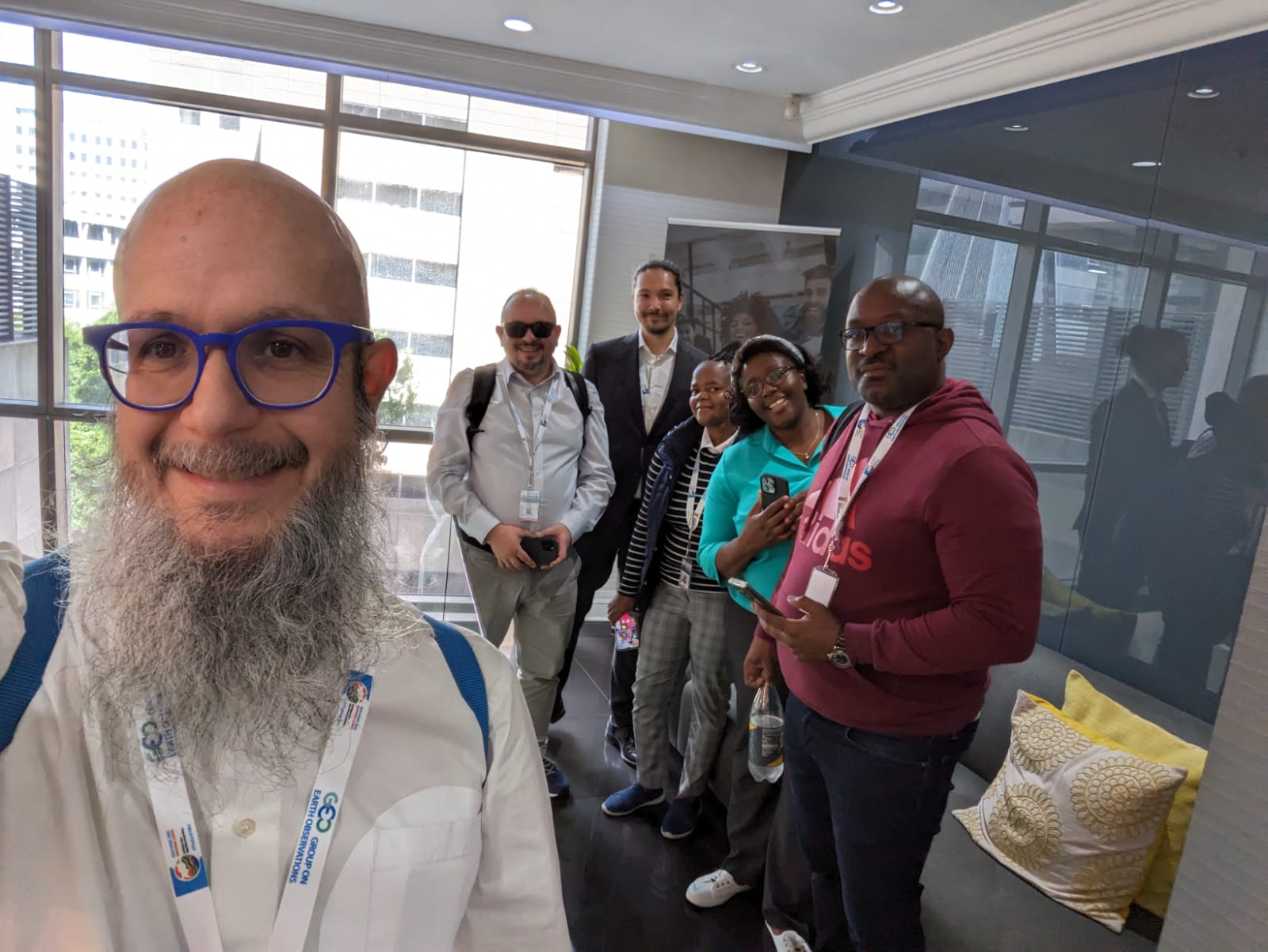
During the first two days of the event, the ANIN project, in collaboration with local partners, hosted a compelling side event within the consortium. This session provided a platform for in-depth discussions, fostering collaboration and knowledge exchange among ANIN Project experts and regional stakeholders. The valuable insights gained during this gathering added a layer of richness to the subsequent discussions at the round table, further amplifying the impact of the ANIN Project.
At the EU Booth on Wednesday, 8 November, at 13:30 h, ANIN Project experts engaged in a fruitful discussion, shedding light on the project's contributions to leveraging Earth Observation data for sustainable agriculture. The session explored innovative tools developed by ANIN to support food security and safety, marking a significant stride towards a more resilient agricultural landscape in Africa.
During the week, the ANIN team held a workshop attended by the South African Weather Service (SAWS) and the Department of Water and Sanitation (DWS). This joint effort aimed to enhance synergies between Earth Observation and Meteorological and Hydrological data. The workshop facilitated a knowledge exchange, emphasizing the shared commitment of SAWS and DWS to strengthen South Africa's water and weather management systems as well as for the definition [1] of the capacity development plan and [2] the roadmap and milestones for 2024.
We extend our gratitude to all participants and collaborators for making this event a success. To delve deeper into the insightful discussions and advancements presented during the round table.
Stay tuned for more updates as the ANIN Project continues to play a pivotal role in harnessing Earth Observation for the benefit of African agriculture.
ANIN Story Map (Draft version)
Documents
DOCUMENT
LINK
State-of-the-art
D3
Policy review
D4
ATBDs and products specifications
D8
Associate documentation of processors toolbox SW
Coming soon (2024)
User Handbook
Coming soon (2024)
Consortium

GMV
VITO
AgroApps
HATFIELD
South African Partners
![]()
DWS
![]()
DALRRD
SAWS
![]()
ARC
![]()
SANSA
![]()
CCARDESA
Contact